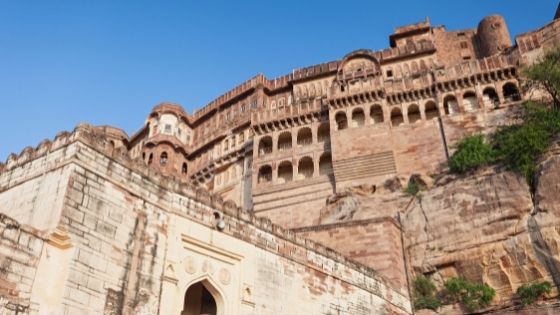
INTRODUCTION:-
The Sondai Fort of Karjat is a real gem. It is not a famous place, but you will undoubtedly get accolades! This fort is included in the Matheran range. After scaling the granite patch, two pools can be seen, each with a massive pillar. The Matheran mountain range can be clearly seen from above. During monsoon, expect lush green scenery and misty peaks too! Sondai is not a famous fort, near Karjat Chowk Phata. Karjat railway station is nine kilometers away from the Sondai Fort trek. More Dam, Prabalgarh, Irshalgarh, Rajmachi, Songiri Fort, Karnala Fort, and the Matheran mountain range can all be seen from here. Sondai Fort Trek has located about 9 km from Karjat in the Raigad district. It was built close to the Karjat and Matheran mountain ranges.
COMPLETE GUIDE TO SONDAI FORT TREK AND MATHERAN VIA:-
Now the footpath leading to the southwest of the Sondai Fort was barely a foot wide. To our left, the hill rose sharply, while the valley to our right, vanished equally rapidly into the emptiness of the fog. The blanket of fog around us immediately dissipated and a lush green katwan valley was visible, shimmering in the morning light. A little further ahead, several bright rays of sunlight were running through the clouds to illuminate the bright blue stream. To its left, the majestic Morbe Reservoir, calm as ever, completed the spectacle by blending gently into the pale blue sky on the horizon.
SONDAI FORT TREK FROM SONDEWADI:-
From Sondewadi, turn right along the unpaved path leading towards the fort. About 300 meters from the hamlet, Look for a wide exit from the right side of the road. The trail climbs up a gentle plateau before turning left towards the fort. The western side of the fort has a slightly open traverse after an easy rock patch. A U-turn after the traverse leads to the shoulder of the hill. Two sturdy stairs set up on a tricky rock patch near the top make it a perfect trek for beginners. Go down that route.
MATHERAN VIA RAMBAUG POINT TREK FROM POKHARWADI:-
From Pokharwadi, proceed over the concrete bridge over the Katwan stream and climb a trail on your right. This trail meets an unpaved road that extends to Burujwadi. A trail leads through the paddy fields in front of the wadi. And at the base of Rambagh spur, it meets Borichi Gani (Dhangarwada). Turn left and climb along the spur to reach the tiled bench post on the perimeter of the Rambagh forest. From the outpost, the trail climbs gently up the cliff through the dense forest and ends at the Rambagh Point Viewing Gallery. You can board a narrow gauge train from Matheran to Aman Lodge or walk from Rambagh Point to Dastoori Naka (about 5 km).
FOOD AND WATER:-Food and water are available in Pokharwadi, Sondewadi, and Matheran. The water tank at Sondai Fort may or may not contain potable water.
ACCOMMODATION:-Overnight arrangements can be made in schools or homes in Pokharwadi and Burujwadi. Alternatively, you can stop/camp in Matheran after the trek.
ALTERNATIVE ROUTES:-
Wavarle GAON TO SONDAI FORT:-There exists another slightly longer route to the fort from the village of Bavaria,2 km south of Sondai. Walk from the village to Vavrale Dam and proceed north to reach Vavrale Thakarwadi. Cross a small hill and a seasonal stream to reach the clearing where it meets the trail from Sondewadi.
THE AFTERMATH OF CHANDERI TREK:-
Chanderi Fort Trek is located near Thane in the Badlapur region of Maharashtra. It is not really a fort. Because there are no fortifications. But some water bodies, caves, and Since the route to Chanderi Fort is very difficult, it seems that this place was used as a military base. The history of this fort is not very well documented, although it is notable as the jewel in the crown of forts in the Raigad district. The remains of fortifications can be found near the caves. Perhaps this is the only feature that can classify Chanderi as a fort. In 1656 Shivaji Maharaj conquered all the territories up to Kalyan Bhiwandi-Rairi, this was when the fort came under the rule of the Marathas. The low water storage area and the absence of important constructions suggest that it was probably a military base rather than a fort.
THE MATHERAN QUEST:-
The base of the Matheran trek is within walking distance of about 2 km from the bus stand. This area is incredibly green in monsoon, In which flat plains merge with the slopes, rising into the distant lush mountains, each wrapped in silver ribbons of springs. The direction of the springs was blowing with the wind, the flow of water from the springs was not thick, But the fine mist showers, each time deflected and redirected, as if the mountain had its mouth and was blowing over them!


